NISAR for Dummies: Lets unpack the NASA-ISRO collaboration
- Aman Kumar Singh
- Jul 30
- 8 min read

Updated: Aug 26
Hi everyone! When I heard about the launch of NASA-ISRO Synthetic Aperture Radar (NISAR) mission, I was very excited. It was supposed to launch last year in 2024 but due to technical failure, it was delayed, and now it is launching today, July 30, 2025 at 5:40 PM IST, from India’s Satish Dhawan Space Centre.

This blog is for understanding the mission of NISAR, starting with the basics for anyone curious, and explaining why it’s a massive leap forward compared to previous Earth imaging satellites.
The Basics: What’s NISAR and Why Should You Care?

NISAR, a joint mission between NASA and ISRO, is designed to scan the entire Earth every 12 days, detecting even the tiniest changes on the planet’s surface, from a 1 centimeter shift caused by an earthquake to the slow, steady retreat of glaciers. It’s the most expensive Earth-imaging satellite ever built, with a $1.5 billion price tag, and for good reason.
Why does it matter? NISAR has the potential to be an early warning system for natural disasters like floods, track the pace of ice melt in Antarctica, and monitor tectonic activity with unprecedented accuracy.
It has a powerful radar system that can classify sea ice, detect ships, monitor shorelines, analyse storm patterns, measure changes in soil moisture, map surface water resources, and aid in rapid disaster response. In short, it’s a Swiss Army knife for Earth science.
Whether you’re a farmer looking for soil data, a scientist tracking volcanic activity, or simply someone who cares about the future of our planet, NISAR is working for you.
And perhaps most inspiring of all? It’s a shining example of U.S.-India collaboration, a testament to what’s possible when two nations come together in the spirit of innovation and shared purpose. As someone who’s seen the passion for progress in both countries, that’s something to be proud of.

How NISAR Works

NISAR stands for NASA-ISRO Synthetic Aperture Radar. The “Synthetic Aperture Radar” (SAR) part is key. Unlike regular cameras that need sunlight, SAR sends out radar waves and listens for the echoes bouncing back. It’s like shouting in a canyon and timing how long it takes to hear your voice. This lets NISAR create super detailed images of Earth’s surface, even through clouds or at night.
What makes NISAR special is its dual-frequency radar. It is the first satellite to use both L-band (1.25 GHz, 24 cm wavelength) and S-band (3.2 GHz, 12 cm wavelength).
Check the figure below on the left side. L-band’s longer wavelength can peer through thick forests to see the ground, while the S-band’s shorter waves are great for spotting finer details like crop health or soil moisture. NASA built the L-band system, and ISRO handled the S-band, making this a tag team effort.

How NISAR Stands Out
So, is NISAR just another mission, or is it truly better than what came before? Spoiler alert: it’s a game-changer. Let’s compare it to previous Earth-imaging satellites to see why. Missions like Landsat (optical imaging), Sentinel-1 (C-band SAR), and ALOS-2 (L-band SAR) have been great, but NISAR takes things to a whole new level.

1. Dual-Frequency Radar: A First in Space
NISAR is the first satellite to combine L-band and S-band SAR in one mission. Earlier satellites like Sentinel-1 (C-band, 5.4 GHz) or ALOS-2 (L-band only) used a single radar frequency, limiting what they could see.
For example:
Sentinel-1: Great for ocean and ice monitoring but struggles to penetrate dense vegetation due to its shorter C-band wavelength (5.6 cm). It’s less effective for things like forest biomass or deep soil studies.

ALOS-2: Uses L-band, which is awesome for seeing through forests, but lacks the S-band’s ability to capture fine surface details like crop health or soil moisture at high resolution.

NISAR’s dual-band setup means it gets the best of both worlds: L-band’s deep penetration for forests and glaciers, and S-band’s precision for agriculture and surface changes. This makes it way more versatile than any predecessor.
2. High Resolution and Coverage

NISAR uses an approach called SweepSAR. SweepSAR works by transmitting radio waves to the entire swath, receiving echoes from parts of the swath in quick succession within a thousandth of a second, then processing them simultaneously and combining them. The transmission signal is sent out between the echoes being received. It uses a 12-meter antenna and the scanning method to cover a 240 km swath, way wider than most SAR satellites, while still achieving 5 to 10 meter resolution.
Compare that to:
Landsat: Optical sensors with 30-meter resolution, limited by cloud cover and daylight.
Sentinel-1: Offers 5–20 meter resolution but with a narrower swath (up to 400 km in some modes, but not consistently high-resolution across such a wide area).
ALOS-2: L-band SAR with 10-meter resolution but a much smaller swath (50–70 km).

3. All-Weather, Day-and-Night Imaging
While optical satellites like Landsat or MODIS need clear skies and sunlight, NISAR’s SAR can see through clouds, smoke, and darkness. Sentinel-1 and ALOS-2 also use SAR, but NISAR’s dual-frequency system makes it more robust. For instance, S-band is less affected by ionospheric noise in polar regions, while L-band cuts through dense vegetation better.
4. Sensitivity to Tiny Changes
NISAR’s interferometric SAR (InSAR) can detect surface changes as small as 1 cm. It does it by comparing radar images at different times to spot tiny changes. Imagine taking two photos of your backyard a week apart and noticing a new crack in the ground, that’s what InSAR does, but for the whole planet.
How InSAR Works
Send and Receive: NISAR’s radars send out polarized radio waves (horizontal or vertical) and measure how they bounce back. Different surfaces (like rock, water, or plants) reflect these waves differently, giving clues about what’s down there.
Compare Images: By comparing two images of the same spot taken days apart, NISAR detects changes in distance to the ground. If the ground moves up or down (say, before an earthquake), the radar wave’s phase shifts, and NISAR catches it.
InSAR for monitoring volcanic activity Video: NASA Phase Difference: The phase difference (Δφ) between two images is used to calculate surface displacement:
where Δh is the displacement, lambda is the radar wavelength, and Δφ is the phase difference.
It is way more sensitive than most predecessors. For example:
ERS-1/2 (1990s): Early InSAR satellites detected changes at 2–3 cm, but with limited global coverage.
Sentinel-1: Can detect 1–2 cm changes but is less effective in heavily vegetated areas due to C-band limitations.
ALOS-2: Matches NISAR’s L-band sensitivity but lacks S-band for broader applications.
5. Massive Data Volume and Accessibility
NISAR’s 9-terabit recorder and 3.5 Gbit/s Ka-band downlink handle up to 85 terabytes of data daily, way more than any previous SAR mission. For comparison, Sentinel-1 generates about 2.5 terabytes daily. Plus, all NISAR data is free within hours (or instantly for disasters), unlike some missions where data access is limited or delayed. This open policy, as highlighted in a 2025 NASA report, makes NISAR a goldmine for scientists, farmers, and disaster responders worldwide. I love this because it means even small research teams in places like India can use cutting edge data without breaking the bank.

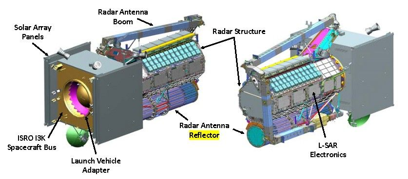
Spacecraft Design and Subsystems
At the heart of NISAR is the spacecraft bus, provided by ISRO, which serves as the backbone for the mission. This octagonal platform houses critical systems for command, data handling, propulsion, and attitude control. Attached to the bus are large solar arrays that fold during launch and deploy in orbit to power the spacecraft’s subsystems, including the power-hungry L-band and S-band radars.
The Attitude and Orbit Control Subsystem (AOCS) is key to NISAR’s precision. It ensures the spacecraft:
Maintains a tight orbital path within 500 meters (1,640 feet) throughout the mission.
Points accurately at a fixed angle relative to the orbit track and Earth’s surface (nadir).
Can manoeuvre to observe both sides of the orbit plane.
The propulsion system carries enough fuel for at least five years of operation, enabling frequent small manoeuvres to maintain the spacecraft’s precise orbit. This ensures NISAR stays within its required orbital "tube" for consistent data collection.

Orbit and Performance
NISAR will operate in a low Earth orbit (LEO) at an altitude of approximately 747 kilometers (464 miles). Traveling at a speed of about 7.6 kilometers per second (17,000 miles per hour), the spacecraft will complete an orbit roughly every 98 minutes, allowing global coverage every 12 days. This sun-synchronous orbit ensures consistent lighting conditions for radar observations.
Apart from 9 TB data recorder and Ka-communcation module, NASA contributes GPS receivers for precise orbit determination and timing, along with a pyro firing system for deploying booms and antennas, and a payload data system to manage communications between NASA and ISRO components.

Launch Configuration
For launch, NISAR’s solar arrays and radar antennas are folded into a compact stowed configuration, as shown in the diagrams below (illustrating two views of the spacecraft). Once in orbit, these components deploy to enable full operation.
The Science and Impact
NISAR’s data will transform how we understand Earth. Here’s why it matters, broken down by its key goals:
1. Disaster Preparedness
NISAR can spot ground shifts before earthquakes or volcanic eruptions. For example, it’ll measure deformation along fault lines, helping predict quakes. NASA report noted that NISAR’s data could cut response times for disasters like tsunamis or landslides by providing near-real-time maps.
2. Climate Change Insights
Ice and Glaciers: NISAR tracks how fast glaciers and ice sheets are moving or melting, critical for understanding sea level rise.
Forests and Carbon: By penetrating vegetation, the L-band radar estimates biomass and carbon storage in forests. This helps us know how much CO2 forests are soaking up, vital for climate policies.
3. Agriculture and Food Security
The S-band radar excels at measuring soil moisture with high precision, even through light vegetation. This capability helps farmers optimize irrigation, predict crop yields, and manage water resources. By providing consistent soil moisture data, NISAR supports stakeholders in ensuring food security, especially in drought-prone regions.
4. Infrastructure Monitoring
NISAR’s sensitivity to tiny deformations enables it to detect subsidence in urban areas, sinking dams, or shifting bridges. An ISRO study demonstrated its potential to identify infrastructure risks, reducing maintenance costs and preventing failures. This makes NISAR a critical tool for urban planners and engineers.
The Technical Challenges
Building NISAR took over a decade, with NASA and ISRO tackling issues like:
Antenna Deployment: That 12m reflector had to be perfect. A 2024 delay happened because NASA needed to upgrade its deployment mechanism to ensure it unfolds flawlessly in space [Times of India, 2025].
Data Volume: NISAR generates terabytes of data daily. NASA’s 9-terabit recorder and ISRO’s Ka-band telecom system were custom-built to handle this [JPL, 2023].
International Coordination: Syncing NASA’s L-band and ISRO’s S-band systems required insane precision. The teams used a shared instrument structure to keep everything aligned.

What’s Next for NISAR?
As of today, July 30, 2025, NISAR is ready to launch on a GSLV Mark II rocket. It’ll spend three years (with a possible two-year extension) scanning Earth, with data flowing to scientists worldwide for free. Exciting times ahead!


Comments